Bluewater Passage Preparations or

How to Sail Off the Edge of the World!

Part 3 — Posted: September 16, 2015

Continued from last week—click here for Part 1, Part 2, Part 4

Offshore Navigation Aboard

GPS will be your primary means of knowing your current location, SOG, COG, etc., whether you use electronic or paper charts.

Electronic Charts—You’ll most likely have electronic charts aboard whether in a dedicated chartplotter or just an iPad and open-ocean navigation can be straightforward. You choose a course to your destination and head in that direction for days or weeks at a time. Sometimes you have an intermediate waypoint or two to avoid a reef or to pick up some favorable currents/weather.

Paper Charts—In making a decision as to whether or not to carry paper charts in addition to the electronic charts here are a few things to keep in mind:

  • Electronic charting is now required on commercial ships and they are no longer required to carry paper charts but commercial chartplotter systems must have complete redundancy. Consumer-level electronic systems are not typically qualified under this requirement so in order to be legal under US jurisdiction you need to carry paper charts (and update them per the weekly Notice to Mariners).
  • Using a chartplotter does not eliminate the need to know how to navigate. When you read stories of chartplotter-caused catastrophes, they have been known to ba caused by not navigating properly. If you don't know how to navigate with paper charts, you should take a navigation class even if you go electronic.
  • Lightning is an often-cited concern about electronics aboard. However, lightning is a shore-related phenomenon and is exceedingly rare on long ocean passages as shown on the adjascent NASA map of lightning frequency.
  • Charts in some areas are not very good. This applies to both electronic and paper (as the electronic charts are typically based on the paper). See the article on Navigation by Google Maps for an example of how charts in Fiji are only somewhat related to the reef locations. Similarly, if you look at the paper chart covering the passage from Vanuatu to Australia, you won’t see any of the intervening atols or reefs (even the Great Barrier Reef). You have to zoom in electronically or look at the higher magnification paper charts to see the hazards.

On Celebrate, we carry a full set of paper charts in addition and plot our location twice a day while under passage. The operational navigation of keeping the boat on course is entirely electronic with the chartplotter at the helm. With the GPS-supplied COG vector, we adjust the autopilot compass-course a degree or two every 15 minutes (when the timer goes off).

Automated Identification System—“AIS” is another key component to safe navigation. The AIS receiver receives the broadcasts from ships and similarly-equipped smaller boats and displays their position and other information on the chart-plotter. If you upgrade to a transponder, your boat will also transmit its position to other ships and boats. With AIS, you will “see” ships as much as twenty miles away but as AIS uses line-of-sight VHF frequencies, range depends on mast heights. On watch, you can sometimes watch a ship alter course to avoid you at 5 to 10 miles away.

Although ships may have a reputation for not maintaining a good visual lookout for cruising sailboats, they are usually very good about checking their AIS display. Most AIS displays also show the “target’s” SOG, COG, and the Closest Point of Approach (“CPA”) and its Time (“TCPA”). Many times, a distant ship appears visually to be on a collision course with your boat but if the AIS tells you the CPA will be over a mile, the AIS is correct unless one of the vessels changes course. The AIS also displays ships’ names so it is much easier to hail them on the VHF if passing instructions are needed (or just to say, “Hello,” if it’s been a week since you’ve seen another vessel).


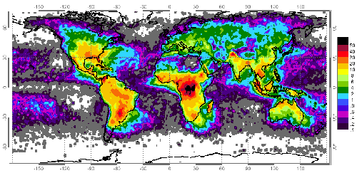
This NASA map shows lightning flashes per year per square-km. In mid ocean years pass without a lightning flash and ground strokes are even less common.


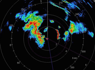
TIP: When you see a squall on radar, place a cursor on it. Check back in 5 minutes to see what direction the squall is moving and how fast (relative to your boat). If the squall is moving away, it is not a problem. If it is moving toward the center of the radar screen, you should prepare for the squall (you don't need to compensate for the boat's course and speed). Bear in mind that high winds develop as much as a mile outside the area of rain shown on the radar.


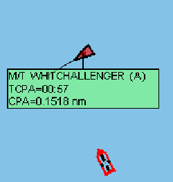
Depending on how big M/T Whitchallenger is, NOW might be a good time to alter course to starboard.


Squalls at sea are common but once you learn to spot them early, you can prepare appropriately.


Weather Gets Worse Sometimes

You should always check the weather predictions before setting out and if your trip is only for a day or two, you might choose to wait until conditions are favorable. But if you’re taking a passage of more than five days, weather predictions become less accurate. Accordingly, choose to sail in seasons when good weather is likely and most of the time you’ll have a pleasant time.

At sea, get daily weather information via SSB, WeatherFax, or SAT Phone. Sources of weather information include: Grib Files, Surface Analysis charts (typical weather maps), and a host of other information. You may subscribe to a weather-routing service for daily updates. If you use the SailMail SSB Service, it includes a convenient way of downloading weather information. All of this information is valuable, particularly in looking for approaching large weather features. It won't give you particular local information and it will only be accurate in a general sense. Wind direction and speed may vary from predictions and local squalls aren't predicted at all. There is no substitute for looking at the sky (and wind instruments) to predict the weather you'll sail by today.

For those occasions where less-than-great weather can’t be avoided, you’ll need to be prepared. Here are some ideas:

  • Install jacklines so that (with the tether on your offshore life-vest) you can go from cockpit to bow and stern on either side of the boat while always being attached. Flat nylon webbing is better than rope for jacklines.
  • Make sure you have adequate hand-holds throughout the cabin.
  • If you are prone to seasickness, find a remedy which works for you. We use scopolamine patches.
  • Make sure your sleeping accommodations can be adapted to rough weather. On Celebrate, some berths have lee cloths and others are built so you can tuck in safely on either tack. When it’s rough, one of us often sleeps in the salon in the center of the boat where the motion is least.
  • Learn about rough-weather sailing. Sometimes a small course change can make a big difference in the boat’s motion. In approaching South Africa, SSB-downloaded GRIB files showed a low approaching a few days out which would eventually have us sailing close-hauled. By changing course to the south, when the low arrived and the wind changed, we could sail 15 degrees further off the apparent wind for much greater comfort.
  • Expect big seas sometimes. After some time at sea, a 6-12-ft swell can be pleasant and soothing, it all depends on the steepness. Large waves in the ocean are not a problem, steep waves can be—even if they’re relatively small. Again, a course change can make a big difference. If you’re running downwind and down-swell, the concerns are for waves which might break into the cockpit and waves which might push the stern to the side and then roll the boat. Seas will be quite large and steep before this is a danger.
  • Sometimes there is more wind. Especially if you’re going down wind, it won’t be long until 30 kts. is a condition you are used to. If you’re going upwind, it can be unpleasant (depending on the sea-state) so you should be flexible.
  • Practice your procedure for squalls. With a little knowledge and experience, you can see squalls coming (in the sky or on radar), predict how intense they might be by their appearance, and take appropriate action. We track squalls on radar so we know how close they will approach, reef early, and are comfortable with a squall gusting over 50 kts. The good thing about squalls is that even with strong winds, there isn’t usually time for dangerous seas to develop. Properly reefed, your boat can probably take any wind you might encounter—sea state is the potential problem.
  • For more severe conditions, have the correct equipment on board (sea anchor, drogue, etc.) and have a plan on what to do—heaving to for a day is better than wearing out your equipment and your crew.
  • Plan your menu with rough seas in mind. Plan some one-pot meals that don’t require much time in the galley (no slicing and dicing). Plan enough snacks that you won’t go hungry if it gets too rough to cook. When it’s rainy and rough, a cup of hot soup can be particularly inviting, even in the tropics.
  • Even in good weather, the sea may be rough enough that you can get banged up. Be prepaared with a first aid kit and first aid training.

We encountered our worst weather on Celebrate near Cape Hatteras before embarking on our World Circumnavigation. On our first occurrence, the predicted scattered squalls happened to assemble into a massive thunderstorm and we experienced winds over 50 kts for two hours. We ran-off downwind (which was offshore) and made the distance back later. On another occasion, in the anchorage at Cape Lookout (about 70 miles SW of Cape Hatteras) we encountered a few gusts which topped the wind-speed gauge at 99 kts. In this case, Celebrate ran downwind at over 8 kts under bare poles. Fortunately, again, at Cape Lookout, we were protected from the sea-state.

Another thing to keep in mind is that conditions typically go from nice to uncomfortable long before they become dangerous to the boat. A well-found boat can cope with conditions which the crew cannot. But just because the boat remains afloat doesn’t mean that all is well. If rough conditions injure a crew-member, this can become a serious problem.

End of Part 3, to be continued next week.